Cenozoic
Mesozoic
Paleozoic
Mesozoic
Paleozoic
Introduction (here | top)
This page is the product of my effort to understand the geologic history of Washington. I am not a geologist but I took a few courses in college and have since then enjoyed trying to figure the stories rocks and their formations can tell. The information I've compiled here is at best second-hand, synthesizing what I've been able to find online with a focus on the landforms and rock formations I've observed around the state.
Here are some websites and other resources which I have found helpful.
This page is the product of my effort to understand the geologic history of Washington. I am not a geologist but I took a few courses in college and have since then enjoyed trying to figure the stories rocks and their formations can tell. The information I've compiled here is at best second-hand, synthesizing what I've been able to find online with a focus on the landforms and rock formations I've observed around the state.
Here are some websites and other resources which I have found helpful.
Geological Timescale+
Kittitas Valley Field Trip+
Burke Museum PNW Geology +
DNR - Washington Geological Provinces+
Nick Zentner (CWU) lectures and more+
DNR - Washington Glacial Geology+
(Hasenburg 2020+) Recap of lecture by Marli Miller - WA Roadside Geology vignettes
Pleistocene
(Riedel 2021+) Study of Olympic NP coastal landforms
(Holden 2007+) Terraces in Okanogan County
(Cooley 200?+) Great Terrace of the Columbia #2 - The Geologists
(Whitlock 1992+) 20K Year vegetation history of the Pacific Northwest
(Sweeney 2007+) Eureka Flat and the Palouse loess
(Allstädt 2021+) Pliocene/Pleistocene climate in the Pacific Northwest
(Blue Marble 2025+) Geology of the Goat Rocks
Neogene (mostly Miocene/Pliocene)
(Cooley 2023+) Skye Cooley field trip - Calcrete growth in eastern WA
(Lindsey 1996+) Miocene-Pliocene Ringold Formation study
(Moe 2025+) Tertiary history of the Chehalis Basin
(Millar 1996+) Tertiary vegetation history of California
(Mustoe 2001+) Tertiary Flora of Washington+
(Pigg 2002+) Tertiary Flora of Western Washington
Paleogene Geology
(Pearson 1977+) Sanpoil and Related Eocene Volcanics
(Tepper 2023+) Origin of Challis Volcanics
I've organized my findings as a timeline, in part because I'm always curious about how old things
are, be they mountains or rocks, forests or trees or even individual birds. A timeline can be
inconvenient for finding information about a particular landform or roadcut but for the big picture
it provides a helpful frame.
Kittitas Valley Field Trip+
Burke Museum PNW Geology +
DNR - Washington Geological Provinces+
Nick Zentner (CWU) lectures and more+
DNR - Washington Glacial Geology+
(Hasenburg 2020+) Recap of lecture by Marli Miller - WA Roadside Geology vignettes
Pleistocene
(Riedel 2021+) Study of Olympic NP coastal landforms
(Holden 2007+) Terraces in Okanogan County
(Cooley 200?+) Great Terrace of the Columbia #2 - The Geologists
(Whitlock 1992+) 20K Year vegetation history of the Pacific Northwest
(Sweeney 2007+) Eureka Flat and the Palouse loess
(Allstädt 2021+) Pliocene/Pleistocene climate in the Pacific Northwest
(Blue Marble 2025+) Geology of the Goat Rocks
Neogene (mostly Miocene/Pliocene)
(Cooley 2023+) Skye Cooley field trip - Calcrete growth in eastern WA
(Lindsey 1996+) Miocene-Pliocene Ringold Formation study
(Moe 2025+) Tertiary history of the Chehalis Basin
(Millar 1996+) Tertiary vegetation history of California
(Mustoe 2001+) Tertiary Flora of Washington+
(Pigg 2002+) Tertiary Flora of Western Washington
Paleogene Geology
(Pearson 1977+) Sanpoil and Related Eocene Volcanics
(Tepper 2023+) Origin of Challis Volcanics
Holocene (the past 11,000 years) - floodplains, headlands, spits, benches and landslides (here | top)
Although in the gological timeframe 11,000 years is a blink of an eye, it has been long enough for for post-glacial processes to significantly alter some areas of the Washington landscape. Changes during the Holocene are generally more obvious west of the Cascades, where surface geology tends to consist of sediment rather than bedrock. Small streams incised narrow gullies while larger rivers forged level floodplains bounded by steep banks in and through sediments left behind by the glacier, particularly in the Puget lowlands. The effects of wave erosion of those same sediments along the shores of Puget Sound are more obvious. Dungeness Spit, formed in just the past 5,000 years from gravel and sand washed out of the bluffs to the west, is an impressive example.
The more powerful waves along the outer coast, particularly along the Olympic Peninsula, have carved steep headlands and sea stacks and eroded flat benches out of compacted sediments and older sedimentary rocks. Studies have estimated that the benches, which form at mean low tide level, have expanded at a rate of as much as 10-20 meters per century since achievement of a rough equilibrium between isostatic and tectonic uplift of the land and rising sea level. (Riedel 2021+) The benches, carved into the steeply-dipping sedimentary rocks along the north coast of the peninsula, particularly intrigue me. I wonder if the processes that form them reflect on a small scale the formation of the continental shelves, though I'm guessing that the latter may be created more by deposition than by erosion.
Landslides and volcanic eruptions have made locally significant changes to the Washington landscape. These include:
Although in the gological timeframe 11,000 years is a blink of an eye, it has been long enough for for post-glacial processes to significantly alter some areas of the Washington landscape. Changes during the Holocene are generally more obvious west of the Cascades, where surface geology tends to consist of sediment rather than bedrock. Small streams incised narrow gullies while larger rivers forged level floodplains bounded by steep banks in and through sediments left behind by the glacier, particularly in the Puget lowlands. The effects of wave erosion of those same sediments along the shores of Puget Sound are more obvious. Dungeness Spit, formed in just the past 5,000 years from gravel and sand washed out of the bluffs to the west, is an impressive example.
The more powerful waves along the outer coast, particularly along the Olympic Peninsula, have carved steep headlands and sea stacks and eroded flat benches out of compacted sediments and older sedimentary rocks. Studies have estimated that the benches, which form at mean low tide level, have expanded at a rate of as much as 10-20 meters per century since achievement of a rough equilibrium between isostatic and tectonic uplift of the land and rising sea level. (Riedel 2021+) The benches, carved into the steeply-dipping sedimentary rocks along the north coast of the peninsula, particularly intrigue me. I wonder if the processes that form them reflect on a small scale the formation of the continental shelves, though I'm guessing that the latter may be created more by deposition than by erosion.
Landslides and volcanic eruptions have made locally significant changes to the Washington landscape. These include:
1980 Mount St Helens eruption
~1460 Bonneville landslide
5.6 Ka Osceola Mudflow between Enumclaw west to Tacoma and northwest to Tukwila
Statewide, the biggest and most obvious change in the landcape would have to be the changes to
the plant communities from those adapted to the cold dry conditions at the edge of the ice to
those dominant in the state until white settlers arrived - temperate rain forest on the west side
and dry coniferous forest, sagebrush steppe and prairie on the east side. The story of those
changes is considerably more complex than I've implied here. For one thing plant communities don't
migrate intact; instead they are dynamically reconstituted in any given environmental niche as
individual species migrate into suitable habitat.
(Whitlock 1992+)
~1460 Bonneville landslide
5.6 Ka Osceola Mudflow between Enumclaw west to Tacoma and northwest to Tukwila
Pleistocene (0.1 - 2.6 Ma) - drumlins, coulees, terraces, scablands, volcanoes and loess (here | top)
Much of the current topography of Washington developed during the Pleistocene, thanks primarily to the multiple episodes of continental glaciation+ which define the period. During the most recent episode, the Fraser, the Cordilleran ice sheet covered the northern half of the state for as much as 10,000 years and extended as far south as Spokane and Wenatchee on the east side of the Cascades and the Olympia area in the Puget Sound Basin. Receding between 15,000 and 11,000 years ago, the ice left numerous topographic features in its wake, including elongated north-south trending sediment ridges called drumlins in Seattle and almost everywhere else in the Puget Lowlands+, and broad outwash channels south of Olympia.
East of the Cascades the legacy of the ice sheet+ is even more obvious. The Channeled Scablands of the Columbia Basin reveal the pathways and power of the Missoula floods which repeatedly scoured eastern Washington from Spokane to Pasco. The Grand Coulee (including Dry Falls) and other coulees in north central Washington testify to the power of floods from, and redirection of the Columbia River by, the Cordilleran and earlier ice sheets. From Conconully on the eastern edge of the North Cascades to Newport on the Idaho border, the same ice sheets carved a series of valleys aligned from north to south through the highlands between the Canadian border and the Columbia Plateau.
Lining the Columbia and Okanogan River valleys are prominent terraces composed of sand, gravel and larger stones which washed off the surrounding highlands (and from on, in and under the glacier itself). Some formed as material accumulated in gaps between the ice and the steep valley sides. Others originated as deltas deposited in temporary lakes dammed up by the ice. Perched at multiple levels above the current valley floor, the terraces record the progressive wasting away of the tongues of ice which lingered in the valleys (I assume) after the thinner ice over the highlands had melted.
Ice was not the only factor transforming the Washington landscape during the Pleistocene. About 50 miles off the current Washington coast the San Juan plate of oceanic crust has been sliding eastward under the continental crust of western Washington for more than 40 million years. The five major Cascade volcanoes+ are made of magma melted from the descending slab. None of the existing peaks are older than one million years, and within another million they will likely be eroded down to their roots like their predecessors. Among those are the peaks of the Goat Rocks, remnants of a range of volcanoes active earlier in the Pleistocene. At least one was as large as Mount Hood.
Another Pleistocene phenomenon, particularly in eastern Washington, was dust. In a pattern repeated at the close of each ice age, outwash streams carried sand and silt down to the lower Columbia Basin where wind picked it up, carried it northeast and deposited it in the Palouse to add to hills of loess (rhymes with puss, according to some authorities). The hills are not dunes; they are shaped at least partly by erosion, including seasonal accumulation and melting of snow on their north and northeast faces, and they are not homogeneous but are composed of multiple deposits capped by soil horizons developed during interglacial periods over the past 1.5+ million years. Since the advent of intensive cultivation 140 years ago, some areas of the Palouse have lost as much as a meter of the top, most fertile, soil horizon. (Veseth 1985+)
In Washington the rainshadow effects continued to intensify with the continuing, and probably accelerating, uplift of the Cascades+, important evidence for which is the formation of subsoil layers of Calcium Carbonate (Calcrete) across the Columbia basin. (Cooley 2023+) The range isn't rising uniformly; uplift of the North Cascades be as much 15,000 feet, three times that of the southern Washington Cascades. Concurrent with the Cascades uplift has been the development of the Yakima fold belt, the series of east-west trending ridges between the Kittitas valley and the Oregon border extending east from the Cascades to Othello and Walla Walla. These are anticlinal folds with thrust faults at the base of their north slopes. Holocene earthquakes suggest the uplift and compression is continuing. Both are related somehow to the ongoing subduction of the Juan de Fuca plate off the coast. I'm curious as to whether the half-dozen or so ridges all rose at once, or did the folds start in the south and replicate to the north, or vice versa?
Much of the current topography of Washington developed during the Pleistocene, thanks primarily to the multiple episodes of continental glaciation+ which define the period. During the most recent episode, the Fraser, the Cordilleran ice sheet covered the northern half of the state for as much as 10,000 years and extended as far south as Spokane and Wenatchee on the east side of the Cascades and the Olympia area in the Puget Sound Basin. Receding between 15,000 and 11,000 years ago, the ice left numerous topographic features in its wake, including elongated north-south trending sediment ridges called drumlins in Seattle and almost everywhere else in the Puget Lowlands+, and broad outwash channels south of Olympia.
East of the Cascades the legacy of the ice sheet+ is even more obvious. The Channeled Scablands of the Columbia Basin reveal the pathways and power of the Missoula floods which repeatedly scoured eastern Washington from Spokane to Pasco. The Grand Coulee (including Dry Falls) and other coulees in north central Washington testify to the power of floods from, and redirection of the Columbia River by, the Cordilleran and earlier ice sheets. From Conconully on the eastern edge of the North Cascades to Newport on the Idaho border, the same ice sheets carved a series of valleys aligned from north to south through the highlands between the Canadian border and the Columbia Plateau.
Lining the Columbia and Okanogan River valleys are prominent terraces composed of sand, gravel and larger stones which washed off the surrounding highlands (and from on, in and under the glacier itself). Some formed as material accumulated in gaps between the ice and the steep valley sides. Others originated as deltas deposited in temporary lakes dammed up by the ice. Perched at multiple levels above the current valley floor, the terraces record the progressive wasting away of the tongues of ice which lingered in the valleys (I assume) after the thinner ice over the highlands had melted.
Ice was not the only factor transforming the Washington landscape during the Pleistocene. About 50 miles off the current Washington coast the San Juan plate of oceanic crust has been sliding eastward under the continental crust of western Washington for more than 40 million years. The five major Cascade volcanoes+ are made of magma melted from the descending slab. None of the existing peaks are older than one million years, and within another million they will likely be eroded down to their roots like their predecessors. Among those are the peaks of the Goat Rocks, remnants of a range of volcanoes active earlier in the Pleistocene. At least one was as large as Mount Hood.
Another Pleistocene phenomenon, particularly in eastern Washington, was dust. In a pattern repeated at the close of each ice age, outwash streams carried sand and silt down to the lower Columbia Basin where wind picked it up, carried it northeast and deposited it in the Palouse to add to hills of loess (rhymes with puss, according to some authorities). The hills are not dunes; they are shaped at least partly by erosion, including seasonal accumulation and melting of snow on their north and northeast faces, and they are not homogeneous but are composed of multiple deposits capped by soil horizons developed during interglacial periods over the past 1.5+ million years. Since the advent of intensive cultivation 140 years ago, some areas of the Palouse have lost as much as a meter of the top, most fertile, soil horizon. (Veseth 1985+)
In Washington the rainshadow effects continued to intensify with the continuing, and probably accelerating, uplift of the Cascades+, important evidence for which is the formation of subsoil layers of Calcium Carbonate (Calcrete) across the Columbia basin. (Cooley 2023+) The range isn't rising uniformly; uplift of the North Cascades be as much 15,000 feet, three times that of the southern Washington Cascades. Concurrent with the Cascades uplift has been the development of the Yakima fold belt, the series of east-west trending ridges between the Kittitas valley and the Oregon border extending east from the Cascades to Othello and Walla Walla. These are anticlinal folds with thrust faults at the base of their north slopes. Holocene earthquakes suggest the uplift and compression is continuing. Both are related somehow to the ongoing subduction of the Juan de Fuca plate off the coast. I'm curious as to whether the half-dozen or so ridges all rose at once, or did the folds start in the south and replicate to the north, or vice versa?
Pliocene (5.3 - 2.6 Ma) (here | top)
At the beginning of the Pliocene the climate, both local and continental, was warmer and more humid with less seasonal variation than at present though early in the period a shift to the current summer-dry climate began. The contrast between eastern and western Washington climate and vegetation developed as the Cascade range, augmented from around 4 Ma by volcanoes, rose high enough to cause a rainshadow. The Pliocene Cascades, unaffected yet by alpine glaciation, probably resembled the Willapa Hills of southwest Washington - narrow forested ridges dissected by narrow stream valleys - shaped by stream erosion, chemical weathering and mass wasting.
I tend to imagine the Columbia Basin in the early Pliocene prior to significant uplift of the Saddle Mountains as a broad flat plain of nearly-naked basalt but it wasn't so. Rivers flowed south and west over the basalt flows both during and after their emplacement, depositing hundreds of feet of braidchannel, low-gradient riverbed, floodplain, delta and lakebed sediments from the east edge of the rising Cascades to the west edge of the Palouse slope. The primary source was the ancestral Columbia River, which flowed for part of this time through Yakima and Goldendale, then was dammed by the uplift of the Horse Heaven Hills to form a lake spanning the Pasco basin before finding (cutting?) a passage through the ridge at Wallula Gap. The sediments accumulated without interruption from 8.5 to 3.6 Ma to form the fosil-rich Ringold Formation+ as well as correlated formations in the Horse Heaven Hills, Umatilla Basin and farther west. (Lindsey 1996+)
Summer-dry climate with eastside rainshadow
At the beginning of the Pliocene the climate, both local and continental, was warmer and more humid with less seasonal variation than at present though early in the period a shift to the current summer-dry climate began. The contrast between eastern and western Washington climate and vegetation developed as the Cascade range, augmented from around 4 Ma by volcanoes, rose high enough to cause a rainshadow. The Pliocene Cascades, unaffected yet by alpine glaciation, probably resembled the Willapa Hills of southwest Washington - narrow forested ridges dissected by narrow stream valleys - shaped by stream erosion, chemical weathering and mass wasting.
I tend to imagine the Columbia Basin in the early Pliocene prior to significant uplift of the Saddle Mountains as a broad flat plain of nearly-naked basalt but it wasn't so. Rivers flowed south and west over the basalt flows both during and after their emplacement, depositing hundreds of feet of braidchannel, low-gradient riverbed, floodplain, delta and lakebed sediments from the east edge of the rising Cascades to the west edge of the Palouse slope. The primary source was the ancestral Columbia River, which flowed for part of this time through Yakima and Goldendale, then was dammed by the uplift of the Horse Heaven Hills to form a lake spanning the Pasco basin before finding (cutting?) a passage through the ridge at Wallula Gap. The sediments accumulated without interruption from 8.5 to 3.6 Ma to form the fosil-rich Ringold Formation+ as well as correlated formations in the Horse Heaven Hills, Umatilla Basin and farther west. (Lindsey 1996+)
Summer-dry climate with eastside rainshadow
Miocene (23 - 5.3 Ma) (here | top)
28-25 Ma Cascades just low hills west of current crest w/ remains of older volcanoes - Tieton, Fife Pks?, Ohanepecosh (28 Ma?)
20 Ma Early to mid-Miocene climate was moist, warm-temperate and similar east and west
Mid-Miocene: Basalt replaced by andesite, folding formed basins (Puget, Chehalis, Napavine, Portland?) followed by early Cascades uplift ()28-25 Ma Cascades just low hills west of current crest w/ remains of older volcanoes - Tieton, Fife Pks?, Ohanepecosh (28 Ma?)
20 Ma Early to mid-Miocene climate was moist, warm-temperate and similar east and west
18 Ma Olympic Peninsula uplift began (WA-DNR How the Olympics Formed+) 17-12 Ma Most Cascades volcanism paused during CRB eruptions.
16.3-15.6 Ma Columbia River Basalts, esp very large Grande Ronde, later Saddle Mountain, flowed down Columbia, also a few smaller gaps to the north? Petrified tree species include >50% conifers (Spruce, Fir, Douglas Fir, Yew, Bald Cypress) but include Oak, Maple, Birch, Elm, Sweetgum, Tupelo, Sycamore. (Mustoe 2001+) 15 Ma Disappearance of broadleaf deciduous trees from fossil record indicates shift to drier climate (Mustoe 2001+) 12-8.5 Ma Uplift of Hog Ranch/Naneum Ridge anticline forced the Columbia River east from the east edge of the ancestral Cascades west to its modern location, resulting in Ringold deposition. (Lindsey 1996+) 7-4 Ma Modern Cascade uplift began
Oligocene (34 - 23 Ma) (here | top)
Paleofloras from Blakely Fm near Seattle and Gumboot Mt near St Helens contain temperate genera - maple, walnut, hickory, witch hazel (Pigg 2002+)
Paleofloras from Blakely Fm near Seattle and Gumboot Mt near St Helens contain temperate genera - maple, walnut, hickory, witch hazel (Pigg 2002+)
Eocene (56 - 34 Ma) (here | top)
 55-50 Ma Around 55 Mya the northward migration of the Kula-Farallon spreading ridge had reached the
Pacific Northwest, by which time the Siletzia large igneous province has begun to form. The
Siletzia and Crescent terranes now form the basement of the Pacific Northwest from the California
border to Vancouver Island and from the Cascades to the coast. Composition is mostly marine
tholeitic (spreading ridge) basalt interbedded or underlain, perhaps due to thrust faulting, by
contintinental sediment. The best data suggest ages ranging from 56 Mya in the south to ~48 Ma at
the north end, with accretion to North America, possibly along the trace of the Olympic-Wallowa
lineament, around 50 Mya.
55-50 Ma Around 55 Mya the northward migration of the Kula-Farallon spreading ridge had reached the
Pacific Northwest, by which time the Siletzia large igneous province has begun to form. The
Siletzia and Crescent terranes now form the basement of the Pacific Northwest from the California
border to Vancouver Island and from the Cascades to the coast. Composition is mostly marine
tholeitic (spreading ridge) basalt interbedded or underlain, perhaps due to thrust faulting, by
contintinental sediment. The best data suggest ages ranging from 56 Mya in the south to ~48 Ma at
the north end, with accretion to North America, possibly along the trace of the Olympic-Wallowa
lineament, around 50 Mya.
The source of the massive amount of basalt in Siletzia is uncertain, perhaps the Yellowstone hotspot and /or slab windows derived from subduction of a spreading ridge, but there is general agreement that Siletzia has rotated ~75 degrees clockwise around a northern pivot point into its current location. Accretion of Siletzia coincided with a change from compressional to extensional tectonics, a change from subduction to transform movement between the Kula/Farallon and the North American plates, and more locally, perhaps also the strike-slip displacement between 48 and 42 Mya on the Straight Creek fault. (Zentner various, Wikipedia+, Image from Burke Museum+) 52-44 Ma Around 52-51 the Challis volcanic activity begins from southern BC southeast across northern Washington to south-central Idaho, associated with extension and dikes in not just Washington but also Oregon and into Idaho. The slab window theory has North America overrunning the east-west spreading ridge between the Kula and Farallon plates along with portions of Siletzia. Slab windows over the subducting ridge may initially contributed to Siletzia and subsequently fed the Challis volcanoes and intrusions. By 44 mya the spreading ridge had migrated farther north, Siletzia has accreted and subduction of the Farallon plate has resumed to initiate the ancient Cascade Arc.
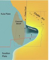
The Challis Arc+ theory describes Challis vulcanism as a volcanic arc derived from the subduction of the Kula plate under the northern edge of the Columbia Embayment. As portrayed in the image above, the Kula plate splits and the eastern fragment subducts while the western fragment initiates transform movemen northward, dragging part of North America with it. (Zentner various, Tepper 2023+, Burke Museum+) 52-42 Ma Chuckanut/Swauk formations are fluvial sand, conglomerate and shale derived from Mt Stuart and mountains east to Idaho, correlated to Puget Group, Roslyn Fm, offset beginning 48 Ma by the Straight Creek fault. Early members contain fossils of subtropical flora - palms, tree ferns, swamp trees and tropical vines. (Mustoe 2001+) Fossils from late Chuckanut Fm indicate a cooler, warm temperate climate (Mustoe 2002+) Coal formed in Chuckanut, Puget Group, Skookumchuck and Roslyn formations of volcaniclastic and fluvial sedimentary deposits. Rank (~hardness) increases with proximity to subsequently-emplaced Cascades plutons. (Walsh 1983+) 49-48 Ma Stonerose Fossil beds deposited in a deep lake filled by progressively coarser sediment in the Republic graben. (Mustoe 2015+) Pollen studies from Eocene Okanogan sediments suggest an upland temperate mixed forest locally dominated by Pseudolarix+, Abies, Alnus, Ulmus, Betula as well as Walnut, Beech and Metasequoiah. (Moss 2025+) 40 Ma Tukwila formation fluvial and deltaic sediments and volcanics on coastal plain by rivers originating in Idaho. Underlies Tiger Mountain continental and marginal sediments, all part of Puget Group. Volcanics correlated to Northcraft Fm. Molluscan fauna similar to Cowlitz Fm, mostly shallow marine in tropical or subtropical climate. (Nesbitt 1998+) 36 Ma The last remnant of the Farallon plate becomes the Juan de Fuca plate after the other remnants are subducted under Alaska, British Columbia and Washington. Shale and turbidites scraped off the subducting Juan de Fuca plate were intensely deformed, thrust under and accreted to the Crescent terrane of Siletzia to form the core of the Olympics. Subduction-driven and perhaps isostatic uplift elevated the Olympic Peninsula above sea level around 18 Mya. Rapid erosion, currently as much as 1 km/million years, stripped off the Crescent basalt exposing the accreted sediments, metamorphosed into the slate and phyllite of the Ozette terrane of the central Olympic Mountains. (WA-DNR How the Olympics Formed+, Juan da Fuca plate+)
Pacific Northwest 55 Mya
The source of the massive amount of basalt in Siletzia is uncertain, perhaps the Yellowstone hotspot and /or slab windows derived from subduction of a spreading ridge, but there is general agreement that Siletzia has rotated ~75 degrees clockwise around a northern pivot point into its current location. Accretion of Siletzia coincided with a change from compressional to extensional tectonics, a change from subduction to transform movement between the Kula/Farallon and the North American plates, and more locally, perhaps also the strike-slip displacement between 48 and 42 Mya on the Straight Creek fault. (Zentner various, Wikipedia+, Image from Burke Museum+) 52-44 Ma Around 52-51 the Challis volcanic activity begins from southern BC southeast across northern Washington to south-central Idaho, associated with extension and dikes in not just Washington but also Oregon and into Idaho. The slab window theory has North America overrunning the east-west spreading ridge between the Kula and Farallon plates along with portions of Siletzia. Slab windows over the subducting ridge may initially contributed to Siletzia and subsequently fed the Challis volcanoes and intrusions. By 44 mya the spreading ridge had migrated farther north, Siletzia has accreted and subduction of the Farallon plate has resumed to initiate the ancient Cascade Arc.
The Challis Arc+ theory describes Challis vulcanism as a volcanic arc derived from the subduction of the Kula plate under the northern edge of the Columbia Embayment. As portrayed in the image above, the Kula plate splits and the eastern fragment subducts while the western fragment initiates transform movemen northward, dragging part of North America with it. (Zentner various, Tepper 2023+, Burke Museum+) 52-42 Ma Chuckanut/Swauk formations are fluvial sand, conglomerate and shale derived from Mt Stuart and mountains east to Idaho, correlated to Puget Group, Roslyn Fm, offset beginning 48 Ma by the Straight Creek fault. Early members contain fossils of subtropical flora - palms, tree ferns, swamp trees and tropical vines. (Mustoe 2001+) Fossils from late Chuckanut Fm indicate a cooler, warm temperate climate (Mustoe 2002+) Coal formed in Chuckanut, Puget Group, Skookumchuck and Roslyn formations of volcaniclastic and fluvial sedimentary deposits. Rank (~hardness) increases with proximity to subsequently-emplaced Cascades plutons. (Walsh 1983+) 49-48 Ma Stonerose Fossil beds deposited in a deep lake filled by progressively coarser sediment in the Republic graben. (Mustoe 2015+) Pollen studies from Eocene Okanogan sediments suggest an upland temperate mixed forest locally dominated by Pseudolarix+, Abies, Alnus, Ulmus, Betula as well as Walnut, Beech and Metasequoiah. (Moss 2025+) 40 Ma Tukwila formation fluvial and deltaic sediments and volcanics on coastal plain by rivers originating in Idaho. Underlies Tiger Mountain continental and marginal sediments, all part of Puget Group. Volcanics correlated to Northcraft Fm. Molluscan fauna similar to Cowlitz Fm, mostly shallow marine in tropical or subtropical climate. (Nesbitt 1998+) 36 Ma The last remnant of the Farallon plate becomes the Juan de Fuca plate after the other remnants are subducted under Alaska, British Columbia and Washington. Shale and turbidites scraped off the subducting Juan de Fuca plate were intensely deformed, thrust under and accreted to the Crescent terrane of Siletzia to form the core of the Olympics. Subduction-driven and perhaps isostatic uplift elevated the Olympic Peninsula above sea level around 18 Mya. Rapid erosion, currently as much as 1 km/million years, stripped off the Crescent basalt exposing the accreted sediments, metamorphosed into the slate and phyllite of the Ozette terrane of the central Olympic Mountains. (WA-DNR How the Olympics Formed+, Juan da Fuca plate+)
References (here | top)
(Allstädt 2021+) Allstädt, F. J.; Koutsodendris, A.; Appel, E.; Rösler, W.; Reichgelt, T.; Kaboth-Bahr, S.; Prokopenko, A. A.; Pross, J., 2021, Late Pliocene to early Pleistocene climate dynamics in western North America based on a new pollen record from paleo-Lake Idaho: Palaeobiodiversity and Palaeoenvironments v 101, p 177-195 (Cooley 2023+) Cooley, S., 2023, Calcrete Growth in Alluvial Lowlands - New Findings in Eastern Washington State: Cooley Geoscience (blog) March 2023 (Lindsey 1996+) Lindsey, K. A., 1996, The Miocene to Pliocene Ringold Formation and Associated Deposits of the Ancestral Columbia River System, South-central Washington and North-central Oregon: Washington DNR Open-File Report 96-8 (Millar 1996+) Millar, C. I., 1996, Tertiary Vegetation History: U.S. Geological Survey Digital Data Series DDS-43 (Miller 2020+) Hasenburg, C., 2020, Washington State: Land of Geologic Complexity (based on the February 14, 2020 lecture by Dr. Marli Miller): GSOC Newsletter March 2020 (Moe 2025+) Moe, R. L., 2025, The Geologic History of the Chehalis Forearc Basin, Washington State, USA: Dissertations and Theses. Paper 6892 (Moss 2025+) Moss, P. T.; Greenwood, D. R.; Archibald, S. B., 2002, Regional and local vegetation community dynamics of the Eocene Okanagan Highlands (British Columbia – Washington State) from palynology: Canadian Journal of Earth Sciences v 42, no 5, Abstract (Mustoe 2001+) Mustoe, G. E., 2001, Washington’s Fossil Forests: Washington Geology v 29, no 1/2, p 2-20 (Mustoe 2002+) Mustoe, G. E., 2002, Hydrangea Fossils from the Early Tertiary Chuckanut Formation: Washington Geology, v 30, no 3/4, p 17-20 (Mustoe 2015+) Mustoe, G. E., 2015, Geologic History of Eocene Stonerose Fossil Beds, Republic, Washington, USA: Geosciences v 5, no 3, p 243-263 (Nesbitt 1998+) Nesbitt, E. A., 1998, Marine Fauna of the Middle Eocene Tukwila Formation, King County: Washington Geology v 26, no 1, p 13-19 (Pigg 2002+) Pigg, K. B.; Wehr, W. C., 2002, Tertiary Flowers, Fruits, and Seeds of Washington State and Adjacent Areas—Part III: Washington Geology v 30, no 3/4, p 3-16 (Pearson 1977+) Pearson, R. D.; Obradovic, J. D, 1977, Eocene Rocks in Northeast Washington - Radiometric Ages and Correlation: Geological Survey Bulletin 1433 (Riedel 2021+) Riedel, J.; Sarrantoni, S.; Dorsch, S., 2021, Geomorphology of Coastal Olympic National Park: Natural Resource Report NPS/NCCN/NRR—2021/2260 (Roberts 1958+) Roberts, A. E., 1958, Geology and Coal Resources of the Toledo Castle Rock District Cowlitz and Lewis Counties, Washington: GSA Bulletin 1062 (Sweeney 2007+) Sweeney, M. R.; Gaylord, D. R.; Busacca, A.J., 2007, Evolution of Eureka Flat: A dust-producing engine of the Palouse loess, USA: Quaternary International v 162-163, p 76-96 (Tepper 2023+) Tepper, J. H.; Loewen, M. W.; Caulfield, L. M.; Davidson, P. C.; Ruthenberg, K. L.; Blakely, S. W.F.; Knudsen, D. F.J.F.; Black, D. F.; Nelson, B. K.; Asmerom, Y., 2023, Petrology and geochronology of Cretaceous–Eocene plutonic rocks in northeastern Washington, USA: Crustal thickening, slab rollback, and origin of the Challis episode: GSA Bulletin v 136, no 1/2, p 725-740 (Veseth 1985+) Veseth, R., 1985, Erosion Impacts on the Palouse Misunderstood: PNW Conservation Tillage Handbook Ch 1 (Walsh 1983+) Walsh, T. J.; Phillips, W. M., 1983, Rank of Eocene Coals in Western and Central Washington State: A Reflection of Cascade Plutonism?: Washington DNR Open-File Report 83-16 (Whitlock 1992+) Whitlock, C., 1992, Vegetational and Climatic History of the Pacific Northwest during the Last 20,000 Years: Implications for Understanding Present-day Biodiversity: The Northwest Environmental Journal v8, p 5-28 (Yancey 2013+) Yancey, T. E.; Mustoe, G. E.; Leopold E. B.; Heizler, M. T., 2013, Mudflow Disturbance in Latest Miocene Forests in Lewis County, Washington: Palaios v 28, p 343-358 (Blue Marble 2025+)
(Allstädt 2021+) Allstädt, F. J.; Koutsodendris, A.; Appel, E.; Rösler, W.; Reichgelt, T.; Kaboth-Bahr, S.; Prokopenko, A. A.; Pross, J., 2021, Late Pliocene to early Pleistocene climate dynamics in western North America based on a new pollen record from paleo-Lake Idaho: Palaeobiodiversity and Palaeoenvironments v 101, p 177-195 (Cooley 2023+) Cooley, S., 2023, Calcrete Growth in Alluvial Lowlands - New Findings in Eastern Washington State: Cooley Geoscience (blog) March 2023 (Lindsey 1996+) Lindsey, K. A., 1996, The Miocene to Pliocene Ringold Formation and Associated Deposits of the Ancestral Columbia River System, South-central Washington and North-central Oregon: Washington DNR Open-File Report 96-8 (Millar 1996+) Millar, C. I., 1996, Tertiary Vegetation History: U.S. Geological Survey Digital Data Series DDS-43 (Miller 2020+) Hasenburg, C., 2020, Washington State: Land of Geologic Complexity (based on the February 14, 2020 lecture by Dr. Marli Miller): GSOC Newsletter March 2020 (Moe 2025+) Moe, R. L., 2025, The Geologic History of the Chehalis Forearc Basin, Washington State, USA: Dissertations and Theses. Paper 6892 (Moss 2025+) Moss, P. T.; Greenwood, D. R.; Archibald, S. B., 2002, Regional and local vegetation community dynamics of the Eocene Okanagan Highlands (British Columbia – Washington State) from palynology: Canadian Journal of Earth Sciences v 42, no 5, Abstract (Mustoe 2001+) Mustoe, G. E., 2001, Washington’s Fossil Forests: Washington Geology v 29, no 1/2, p 2-20 (Mustoe 2002+) Mustoe, G. E., 2002, Hydrangea Fossils from the Early Tertiary Chuckanut Formation: Washington Geology, v 30, no 3/4, p 17-20 (Mustoe 2015+) Mustoe, G. E., 2015, Geologic History of Eocene Stonerose Fossil Beds, Republic, Washington, USA: Geosciences v 5, no 3, p 243-263 (Nesbitt 1998+) Nesbitt, E. A., 1998, Marine Fauna of the Middle Eocene Tukwila Formation, King County: Washington Geology v 26, no 1, p 13-19 (Pigg 2002+) Pigg, K. B.; Wehr, W. C., 2002, Tertiary Flowers, Fruits, and Seeds of Washington State and Adjacent Areas—Part III: Washington Geology v 30, no 3/4, p 3-16 (Pearson 1977+) Pearson, R. D.; Obradovic, J. D, 1977, Eocene Rocks in Northeast Washington - Radiometric Ages and Correlation: Geological Survey Bulletin 1433 (Riedel 2021+) Riedel, J.; Sarrantoni, S.; Dorsch, S., 2021, Geomorphology of Coastal Olympic National Park: Natural Resource Report NPS/NCCN/NRR—2021/2260 (Roberts 1958+) Roberts, A. E., 1958, Geology and Coal Resources of the Toledo Castle Rock District Cowlitz and Lewis Counties, Washington: GSA Bulletin 1062 (Sweeney 2007+) Sweeney, M. R.; Gaylord, D. R.; Busacca, A.J., 2007, Evolution of Eureka Flat: A dust-producing engine of the Palouse loess, USA: Quaternary International v 162-163, p 76-96 (Tepper 2023+) Tepper, J. H.; Loewen, M. W.; Caulfield, L. M.; Davidson, P. C.; Ruthenberg, K. L.; Blakely, S. W.F.; Knudsen, D. F.J.F.; Black, D. F.; Nelson, B. K.; Asmerom, Y., 2023, Petrology and geochronology of Cretaceous–Eocene plutonic rocks in northeastern Washington, USA: Crustal thickening, slab rollback, and origin of the Challis episode: GSA Bulletin v 136, no 1/2, p 725-740 (Veseth 1985+) Veseth, R., 1985, Erosion Impacts on the Palouse Misunderstood: PNW Conservation Tillage Handbook Ch 1 (Walsh 1983+) Walsh, T. J.; Phillips, W. M., 1983, Rank of Eocene Coals in Western and Central Washington State: A Reflection of Cascade Plutonism?: Washington DNR Open-File Report 83-16 (Whitlock 1992+) Whitlock, C., 1992, Vegetational and Climatic History of the Pacific Northwest during the Last 20,000 Years: Implications for Understanding Present-day Biodiversity: The Northwest Environmental Journal v8, p 5-28 (Yancey 2013+) Yancey, T. E.; Mustoe, G. E.; Leopold E. B.; Heizler, M. T., 2013, Mudflow Disturbance in Latest Miocene Forests in Lewis County, Washington: Palaios v 28, p 343-358 (Blue Marble 2025+)