10/02/2008 Mostly cloudy, mid 60's, rain late
Weather's turning wet, Indian Summer is ending. The zucchini's are rotting in place, the cherry
tomatoes splitting and the big tomatoes dropping off the vines. Spiders are spinning their last
hurrahs everywhere in the woods and fields. Our vacations are all done. The boys have gone to
school. It's just the two of us and the cat and a couple goats in the field and the long gray
winter approaches. Not that we don't have anything to do. Yesterday evening I got out and mowed
the lawn mowed after a long day of inertia. We still need to buy hay for the goats and oil for us
for the winter. The garden is unkempt. There's several years' worth of stuff around the house to
be filed away and long-deferred maintenance to be done. Making a little progress on that front. A
few days ago we signed a contract to have the roof replaced. Next, in the front yard the multiple
trunks which sprouted 20 years ago after the top of the cedar was pruned are now tall enough to
threaten that new roof in a storm, so they have to go.
It's a little disconcerting that there's nothing coming up on the calendar. Normally I'd have a
marathon or two or three in the near future but with the tendon problem, I don't know when I'll be
able to run another one. Could be a month, or maybe a year. No vacations planned, no milestones
approaching - there's a void in the things-looked-forward-to department right now and as a result
life feels a little flat.
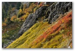
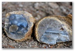
10/06/2008 Little Naches thundereggs trip Ovc, mid 50's, light rain
Pat and Shirley were headed over to Red Top for the weekend so I decided to meet them over there
Saturday morning, dig some agate nodules on the ridge for the day, then drive down to Little
Naches to dig some thundereggs on Sunday. One delay led to another and by the time I was ready
to go Saturday was almost gone. I couldn't contact Pat so decided to go directly to Little Naches.
It's 84 miles to the wide Y in the road at the trailhead. When I arrived, I was the only one
there, though I saw lots of hunters camped along 410 and the Little Naches road on the way over.
Turns out Saturday was opening day of muzzleloader elk season.
I set up camp by the light of the car headlights then hiked up to the diggings because it was too
early for bed. My hole from last year had been recently extended but wasn't too filled in so I dug
there for an hour or so by the light of my headlamp and found a few small eggs. The vein had pretty
well petered out. In the morning I resumed digging in that hole. Beautiful day, sunny and cool
after some light rain overnight. The top couple inches of the tailings piles were damp and pretty
slick but underneath the soil was light and dry. I found a few unbroken eggs there, up to about 5"
diameter, but most were broken. After a couple of hours I moved over to Pat's original hole, about
30' to the west across the slope. I had to move about two feet of dirt and rocks to get down to the
clay but once there I did pretty well, picking up another dozen or so decent eggs by lunchtime,
mostly smallish but a couple up to 6" diameter. Not sure how the color will be on those since the
broken eggs were all pretty pale.
Returning to the car lugging my two bags of eggs, I set up my folding aluminum table and
enjoyed a tomato sandwich with hommous, Greek olives and chips and salsa. I imagine I looked a little
odd to the four dirt-bikers who drove by. I hadn't seen anyone else all day though I heard a couple
of trucks go by around dawn. On my way back to the hole I was able to reach Pat on the phone and
learned that he and Shirley had driven directly home from Red Top after lunch on Saturday. They'd
received heavy rain overnight on Friday night which had resumed around midday after a respite in the
morning. Pat described the location of the productive hole he'd been working in on his last Little
Naches trip, although he said he'd pretty well dug it out. It was about 50' downslope from his
original hole. I couldn't determine which of the big holes down there was his so I resumed digging
in my second hole. About 5' down I was still in clay but not finding any more eggs; they seem to
occur mostly near the veins and ledges of rock which are interspersed with the clay.

Around then company showed up, a man a little older than me lugging a shovel and breathing hard from
the climb up to the diggings. His name was Richard Peet, from the Fort Lewis club I think, and he
seemed new to the spot so I showed him what I was finding and where. We dug a little together in a
couple holes below my original spot then I wandered off to find another hole, ended up over in the
area of Pat's hole, picked one and dug down to new clay. A few inches down into the undisturbed clay I
struck eggs, a cluster of two or three 5" eggs together, and beyond them a bunch more. Within a few
minutes I had half a dozen large eggs and by the time I quit a couple of hours later, I had enough
to fill a 5-gallon bucket. Richard had given up digging and was collecting broken eggs, eventually
filling four 5-gallon buckets which he began slowly hauling back to his car. Around 4:30PM I quit
digging, packed up my gear and my eggs and started out myself, although not before hopping back into
the hole one more time and prying a cantelope-sized egg out of the floor of the hole. It took me
two trips to get it all back to the car. We reached our cars about the same time, around sunset;
before Richard left he gave me a raspberry Twinkie to show his appreciation for my advice. I told
him I'd save it for dessert.
I was wiped out from digging all day but managed to heat up some beans and zucchini before collapsing
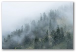
in my sleeping bag for nearly twelve hours. Light rain fell off and on during the night. Towards morning I heard an elk
bugling some distance away and downslope. Clear notes, not as wheezy as I remembered. Also heard a
barred owl higher on the ridge, and around dawn, a pygmy owl. The morning was foggy with intermittent
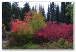
light rain, just enough to make the bushes wet. I spent the day checking out the other Little Naches
sites, none of them worth re-visiting. Along the way I ate lunch at the fish ladder and stopped at a
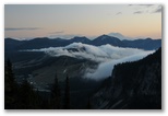
camp area along the river a mile or two upstream to photograph the foliage. Vivid mode helped compensate
for the heavy overcast. I stopped for photos again at Chinook Pass where the clouds were right at pass
level and Saturday night's snow had only partially melted away. Nice color.

The market only dropped 400 points while I was away, though midday Monday it had been down 800 at one
point.
10/08/2008 Sunny, mid 50's
Strange dream the night before last:
I awoke disturbed that I had been beating Jesus on the head
with a hammer. He had been sitting in front of me in a semi-reclining chair like those we used to
have in the den and I'd been standing behind him hitting him on the top of the head with a small
hammer. The hammer wasn't big enough to kill him, although as I continued to beat him the area was
becoming soft and sort of purplish under his matted hair. It was necessary for some reason that I
do it, that I kill him, and he sympathized with me that it was taking longer than it should have.
He even turned to me at one point and handed me the flash drive which he had hanging like a pendant
around his neck. It was the most valuable thing he had and he wanted me to have it after he died.
Once I awoke I couldn't really get back into the dream again although at the time I did recall the
earlier part of the dream, which I think provided a partial explanation for what I was doing. I
tried to fix it in memory but it was gone when I awoke in the morning.
We ran out of oil again yesterday but fortunately the sun was shining so I was able to dry
out the tent and my shoes and boots. Susan fixed a very good Mexican dinner - roasted Poblano
chilis stuffed with corn and cheese on a bed of fried rice, the whole thing laced with creme fraiche
and topped with cheddar cheese. Creamy, sweet and a little hot with a tinge of bitterness from
epazote in the filling. I also cut a couple of the new thundereggs but they just pale beige, tan
and gray inside, without much blue. Bryce from Thundering Oak came by to give me a price
on topping the cedar tree - $720 for taking about 30 feet off the ten or so leaders and trimming
some of the upper lateral branches into the semblance of a crown. He likes petrified wood so I
might cut and polish a piece or two for him. Late yesterday afternoon I did a 7 mile run, my
longest since Maui, and I ran the first 5 at 8:00 pace or better. My anterior tibial tendon started
feeling stiff after 5 miles and was pretty irritable and locally swollen for the rest of the evening
and overnight.
My anterior tib felt much better today, especially in the afternoon. I didn't notice any irritation
while I was out scything grass for the goats. We had oil delivered today, $3.40 per gallon, so now
I can sit at my computer without developing hypothermia. The market continues to drop a couple of
hundred points a day, down to 9260. I'm not sure how low it can go before I have to go back to
work.
Also noteworthy, I roasted the matsutake this evening. While poking around the Little Naches
thunderegg area on Sunday morning, I came across my first matsutake. It was up on top of the ridge,
about 4000', in open mixed lodgepole, fir and Doug fir woods with a low understory of huckleberry
and other shrubs. I should have taken a photo but didn't. I recognized the mushroom immediately,
stocky, white, scaly on top, thick white veil, the stout stem tapering sharply in the ground with
no trace of a bulb or volva. And the fragrance. Hard to describe, but sweet, almost fruity, scarcely
at all fungiferous. Later I decided the scent reminded me of the smell of new leather loafers with
an overlay of tart apple. Anyhow, I cut the mushroom into half-inch slices and baked it unadorned
on aluminum foil in the toaster oven until it started to brown. It was chewy to the point of being
tough with a sweet flavor somewhat reminiscent of the scallops I didn't like when I was a kid. If
they taste anything like the matsutake, I would like them now.

Sunny, 30's
Route Photo Gallery
Tim's heading down to California tomorrow to visit his parents so he could only spare an afternoon
for our hike. We used it all. We started up from Alpental at midday and had just enough light to
get back out of the woods at the bottom. The hike was only a little over three miles even with
taking the scenic route up the valley along Cave Ridge, then up the SE ridge of Snoqualmie and
around behind the crag just east of the summit. Short but sweet and much more interesting than the
direct route up the south ridge - almost a little too interesting for Tim where the snow-covered shelf turns
the corner around the top of a 50' cliff. He didn't look happy about it but he did it.
We both carried cameras but didn't find much photoworthy until a family of camp robbers accosted us
in the talus where the Guye Peak trail turns off. After we delighted them with portions of pb&j
sandwiches they accompanied us up to the waterfall ledges, foraging in the bushes beside us along
the way. At the ledges we stopped for some lunch and the jays were rewarded for their persistence.
Sedum and Arnica were still flowering even though the puddles were iced over and shaded rocks were
dusted with snow.
In the valley we found the streambed still covered with a hard-frozen avalanche deposit from last
winter. Tree tops up to 6" in diameter were strewn about and low ridges carpeted with fir needles
protruded through the inch or two of new snow. The ledges of Cave Ridge glittered with icicles
dripping and falling in the sunshine. We took pictures and dodged the falling ice. At the head of
the valley we found a few alpine huckleberries among the bright red leaves, tangy and soft from
repeated freezing and thawing. Nice views down to Snoqualmie Pass and north to snow-dusted peaks.
Reaching the summit ridge we stepped out of sunshine into a freezing northwest breeze. As we
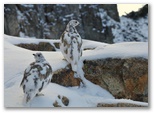
started up the snowy ramp we stumbled on to four white-tailed ptarmigan, their mottled brown and
white plumage matching the colors of rock and snow. Fantastic photo op. I ripped off my gloves to
work the controls on my camera, then my fingers went numb so I couldn't feel the buttons anyhow.
The photos turned out fairly well considering my haste and the cold.
We lingered briefly in the sunshine again on top before heading down the rocky trail. The sun set
about half-way down. We took our last few photos of the fingers of cloud streaming over the pass
below us. Despite the comfortable pace of our descent my quads were pretty fried by the time we
reached the bottom. Fortunately my anterior tib tendon was OK. Down on the rope tow slope we
stopped one more time, propping our cameras on logs to photograph clouds swirling around the moon
over the shoulder of Guye Peak. Frost had already formed on the cab of Tim's pickup.
Found out later that the market bottomed out below 8000 while we were driving up to Snoqualmie, then
recovered to close down just 128 points at 8451. At that price our retirement fund has dropped back
to the vicinity of my "magic number" for the first time in several years. We used to speak at work
of our magic number, the value of our stock and options at which we figured we could safely retire.
The prospect of dropping below that number again made for an uneasy night - the trials of trusting
in mammon.
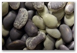
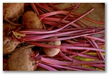
Fresh runner beans
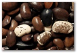
Dried runner beans
Overcast, near 60, rain late
Over the weekend I did some reading and figured that based on historic values of the S&P500
price-earnings multiple, the market could easily drop another 2000 points. In anticipation of that
I picked out several stocks which looked like good sell candidates for Monday, figuring I could
reinvest the cash after the market dropped further. I assumed that everyone else would be spending
their weekend the same way and coming up with similar conclusions so I expected to see the market
down at least a couple hundred this morning. Having stayed up well past midnight again, I gave the
market plenty of time to find its direction before I logged in. Well, it found its direction all
right - straight up. Already up over 500 points by mid-morning. Up 963 points to 9413 by the
close, an all-time one-day record 11% gain. That's an entire year's worth of appreciation in one
day!
I don't know why it is that I feel more discouraged about our finances when the market makes a big
gain than when it drops by a similar amount. Perhaps when it drops I figure if I just sit tight
we'll be all right, but when it goes up I think about all the stocks I could have bought before it
went up, but didn't. In any case I had kind of a down day, reflecting on how little I know about
managing our money even as I researched some of the individual stocks in our portfolio. I didn't
end up selling anything. I didn't end up going for a run either, and didn't get outside to work in
the garden until it started to rain, so I started reorganizing the workshop instead. That's another
big job, made more difficult by my reluctance to throw anything away. I managed to fill a 30-gallon
trash barrel with stuff I haven't used in twenty years, much of it real junk, and felt terrible
about it.
Felt better after Susan and I fixed supper together. I baked a chunk of QFC Coho and steamed the
little zucchinis I salvaged a couple days ago from the frost-killed bushes. Both were very tasty; I
couldn't find the tarragon so used sweet basil on the salmon and that worked fine. Susan baked an
upside-down caramel plum cake, a delicious confection which converted mediocre grocery-store plums
into a work of gustatory art. I also fixed Forbidden rice but it wasn't ready in time so we saved
it for tomorrow. It was a blessing to work in the kitchen together. Although we haven't been
spending an awful lot of time in one another's company since I've been at home all day, the time we
do spend together has a comfortable peaceful feeling about it.
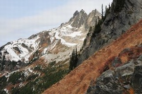
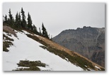
10/19/2008 Snoqualmie Mountain hike #2Increasing clouds, 40's
Photo Gallery
Another sunny weekend after rain during the week. We didn't do much yesterday but today the boys
and I hiked up Snoqualmie Mountain. It was either that or Faye Peak up by Mowich Lake and I figured
out that Snoqualmie would involve less time on the road and a lower fee to park at the trailhead. I
picked the boys up at school around lunchtime so we didn't get an early start. We hiked up the
valley again. I was surprised to find no ice on the Cave Ridge ledges and no snow anywhere this
time, even on the ramp behind the summit crag. David stopped to photograph a snowcave in the
avalanche debris; by following his lead I found my best photos of the day. From the head of the
valley we scrambled up the ledges to the left rather than following the ridge past the crags.
Crumbling granite ledges made the lower section a little sketchy. Up on top we found no ptarmigan
but did see a flock of about 150 grey-crowned rosy finches. Another hiker was hiking up from the
north side of the actual summit, presumably coming cross-country from Snow Lake. We didn't leave
the summit ridge until after 5:30 but took only an hour to descend to the car so we made it out just
before dark. Tough quad workout and a little hard on my left knee. We met Susan at Ranchitos an hour
after leaving the Alpental parking lot then drove home to have pear crisp for desert. Nice to have
the boys home again for a couple of days.
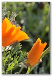
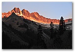
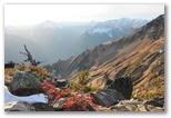
10/26/2008 Sun, mid-50's
Another sunny weekend. The week was mostly dry as well. Wednesday I drove down to Centralia and spent the night
with Pat and Shirley so Pat and I could get out early to go
agate-hunting. We found quite a few although the agates weren't quite as
colorful as the photo at right would lead you to believe.
My anterior tibialis tendonitis continues to improve. I ran ten miles on Friday, my longest run in
five weeks, with no ill effects. Did another five Sabbath morning. I ran part of each run barefoot,
almost five miles in the two runs together. The calf tightness I experienced when I began barefoot
running a couple of months ago has cleared up as have the blisters on my big toe and heel but the
rough pavement around here still limits me to three or four miles at a time. Not sure how to get
beyond that.
Sabbath after my run I made it to church. I went to North Hill since afterwards I needed to pick
David up at school. Pastor McClarty preached on the first three chapters of Revelation. I was
encouraged by his emphasis on grace, as in "Grace to you, and peace from Him who is and who was
and who is to come, and from the seven Spirits who are before his throne, and from Jesus Christ..."
Rev 1:5. He pointed out that some would narrow God's grace so that it applies only to the elect,
or to the obedient, but grace sums up God's attitude to all mankind, sinners as well as righteous.
He also observed that God's criticisms of the seven churches do not indicate that He rejects
them for their failure to perform, but instead they point out the way that He desires them to go,
that they may receive greater blessing. A glass-half-full approach to be sure, but I could use
a dose of that for a change.
The afternoon being a little short for a hike, David and I elected to mountain-bike down to the
river with our cameras, to explore the trail and take some pictures. I managed (with one redo of
the hairpins after the bridge) to ride the entire new trail eastbound even though the tread was
pretty chewed up and mucky in places from horse traffic. We made a loop of it by pushing our bikes
up the trail to the end of the Caitlin's road, then stopped by to say hi to Zack on the way home.
He supports Palin enthusiastically, thinks that she's the kind of leader we need to root out the
corruption on Wall Street which has gotten us into this economic mess. We are at opposite ends of
the political spectrum and that both constrains and enriches our friendship.
It was a cold ride home as the sun set.
Susan fixed a Thai dish of noodles, sweet red peppers and chanterelles with tamarind sauce. It was
delicious but made me very thirsty. After supper I took David home, ie. back to school and hung
out with him and Daniel for a while. Daniel seemed a little morose, which he attributed to fatigue
as he sat with his laptop in his lap debating religous doctrine on Facebook instead of going to
bed, which admittedly would have been a little difficult since David and I were sitting next to him
on his couch looking at David's recent photos. Both boys have cozy and inviting dorm rooms so I was
reluctant to leave even though I was falling asleep myself. I stayed awake on the drive home by
drinking yet more water.
This morning I took a few photos before breakfast as the fog burned off. Beautiful day, sunny and
mild, but I have a bit of a sore throat so I took it easy, weeded the driveway and transplanted the
three remaining Hostas instead of going for a run and ride.
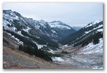
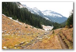
Boulder Basin backpack trip 10/28-30/2008
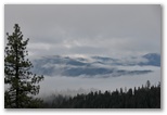
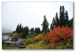
10/28/2008 White River/Boulder River trail 7 mi, 2500' Sunny, high 40's.
Route (miles 0-7)
Photo Gallery
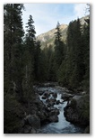
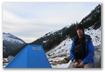
White River at trailhead
I set out from the White River trailhead at 3:45 on a beautiful afternoon though the river valley
was already in the shade. It's about 120 miles and 2 1/2 hours from Seattle via Steven's Pass, the
Lake Wenatchee Hwy and the White River road. Not much color left over the pass but the cottonwoods
were still bright around Lake Wenatchee but the color is pretty well gone in the mountains. I had
intended to start earlier knowing that I had at least a four hour hike in to Boulder Basin where I
wanted to camp, but in my usual reluctance to leave home I answered email and rechecked the weather
and waited for the roofers to show up, then I had several errands - get gas at Costco (down to
2.39/gallon now), pick up a map and a forest parking pass at REI, and stop somewhere for a hunter
orange vest since rifle elk season opened over the weekend.
As it turned out there were no hunters up the White River valley, and not much elk sign either, just
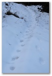
Bear tracks
a few sets of solo tracks wandering across the high country. Deer sign was more common, some of it
fresh though I didn't see any animals. After I crossed the Boulder River, after dark, I came across
a set of cougar tracks in the trail but they were several days old and I hoped the cougar would be
more interested in the deer than in me. The bear tracks heading down the trail below Boulder
Basin were also several days old. The freshest tracks belonged to a couple of coyotes or foxes
which had been playing in the snow near Boulder Basin camp. The Boulder Pass trail was pretty
chewed up in places by horses but no parties had been up that way since the snow fell about a week
ago. There was one hiker ahead of me on the White River trail, presumeably associated with the blue
minivan at the trailhead. I assume the tracks continued up the White River valley because I didn't
see them after I turned off onto the Boulder Pass trail.
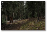
The trail moseys through groves of big trees (and a few groves of big stumps cut before the
area was included in the Glacier Peak Wilderness) and crosses a number of avalanche runouts of slide alder,
vine maple and thimbleberry, mostly bare now. In openings damp dirt in the trail was partly frozen.
The river is rarely within sight. It isn't white, rather more of a clear blue-green hue in pools.
Maybe it was white a few decades ago before the glaciers melted back. The woods were dotted with
mushrooms, flowers of the fall, mostly in pallid shades of white and brown, or rotted black. Now and
then I caught a glimpse of the sunlit slopes of Clark Mountain, nearly free of snow, above the dark
treetops.
I reached the Boulder Pass trail around 5:30 and stopped to rest and eat a couple of bars. There's a nice camp
by the river at that point, and another about an hour up the Boulder Pass trail in the woods before the
Boulder River crossing. By that point I was using my headlamp. The stream crossing, trivial this time
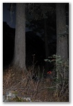
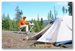
Camp
of year by daylight, was tricky in the dark and I almost got wet feet. Above that point the trail was
filled in with several inches of old snow and trees were few. Above the brush visible by my headlamp I
could dimly make out pale snowfields on high ridges. My shoulders were getting sore from the pack straps
and I began to wonder if I should have camped back in the trees before the crossing, but if I wanted to do
Clark tomorrow I needed to make it fairly high this evening so I kept going. Around 4600' I found a dry
flat hollow between two big firs just above the trail. The air was dry and the spot just big enough for my pad and
sleeping bag so I didn't set up the tent. I was in my bag at 8:30, relieved to be off the trail. Hiking
in the dark makes me a little anxious; I prefer to see what's around me. Knowing a cougar was in the
area didn't help and I was also a little worried about my anterior tibial tendon; it felt a little irritable
during the hike. Hiking doesn't usually bother it so the irritation was probably due to the 11 mile run
yesterday.
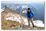
10/29/2008 Clark Mountain 6 mi, 4500' Partly cloudy, high 30's, wind SE-SW, 3-15. Route (miles 7-12.7)
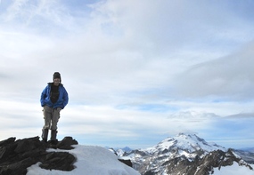
On the summit of Clark Mt
I slept well under the stars, sandwiched between my two big covering firs. I awoke at 1:15 with the
downvalley breeze still blowing cold on my face and the stars bright overhead. The temperature was
around freezing. I supplemented the baffle on my 0F-rated bag by wrapping a pair of long underwear
around my neck and managed to stay pretty comfortable, though not at all too warm. I awoke again as
the dark sky was just beginning to fade into dawn. A dream woke me up, something about the car
brakes not working when I needed to stop. There was more to it than that and as I lay half-asleep
pondering it, I gained clearer insights into the fear which has accompanied me all my life.
Unfortunately I wasn't able to recall either the dream or the insights when I woke up fully at
dawn.
Part of the appeal of solo backpacking for me is the opportunity it provides to cope with tangible
but manageable fears of things such as solitude, darkness, animals and heights. Those fears sharpen
my focus and enrich my experience of the mountains. They make the colors brighter, the sounds more
distinct and each footstep more significant. They offer a refreshing though temporary distraction
from the intangible fear that exerts its authority over my decisions in the weightier matters of
work and goals and relationships. They also tend to turn my thoughts towards God.
While I was awake during the night I thought about the resentment I feel towards God, the anger I
have accumulated towards Him over my failure to meet His demands. But He doesn't condemn me, nor
does He want me to see Him in that light. When a relationship between two people breaks up, the one
who suffers more is the one who loves more. There is no doubt that in my relationship with Jesus, He
is the one who loves more. In the separation from Him which I have been cultivating in my bitterness,
He is the one who suffers. I may not love Him much but I truly do not want to grieve Him either. I
no longer want to cultivate this bitterness towards Him and there between the two firs under the stars
I sought His help to return to Him. I fell back to sleep knowing that I will return to Him. I prayed
for a safe hike too, that I would also return to Susan and the boys who still need me.
Sunrise on the east ridge of Clark Mt above Boulder Basin
Me and my camp
In the morning I packed up a little before sunrise and hiked up into Boulder Basin before breakfast,
seeking a flat spot to camp. At the up-valley edge of the last grove of big trees I passed an
apparent camp but the tent sites were shaded and blanketed with snow so I continued on. In the floor
of the basin I found a gently sloping meadow of golden sedge-straw dotted with boulders and partly
covered with patches of snow. That would have to do because higher up in all directions the slopes
only became steeper. I cleared the crusty snow between several boulders, pitched my tent and ate my
breakfast.
Having seen from down along the White River that the south slopes of Clark Mt were mostly free of

Boulder Basin camp and route
snow, I had decided to go for the summit. I set out around 10AM with food and a few extra clothes
and emergency gear in my fanny pack. My route out of Boulder Basin ascended the talus apron,
scrambled over a rock outcrop, followed a game trail up through a patch of scrubby trees then
traversed up across steep grassy slopes to the horizon, pretty much straight up behind the peak of
the tent in the photo to the right. It was more difficult than it appears so on my descent I hiked
down through the snow from the left side of the shallow notch. It was also more difficult than it
looks in the photo but probably not as bad as descending the steep and slippery slopes of matted
grass I'd crossed on the way up.
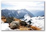
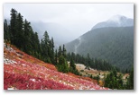
View south over Boulder River and White River valleys from 7000'
Once out of the basin I continued up to a flat spot on the ridge at about 7000' and ate a couple of
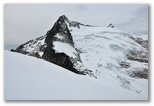
bars there. My next objective was a notch in the southeast ridge of Clark Mt which I had read about
in a
trip report on the web,
and from which a gully drops 200' down to Clark's south slope. This gully provides the only
non-technical way to cross the ridge and gain access to the summit from the east. Somehow I had
understood that the notch was at 7100' on the ridge but it's actually just above 7300'. From the
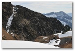
Gully on the SE ridge, from the west
east it doesn't look much like a notch but from the west the 200' gully is obvious, especially when
it is highlighted with snow. Descending the gully was pretty intimidating because if you slid you'd
drop off a couple of small cliffs onto a very steep slope. Fortunately the snow was deep enough to
provide good footing and the cliffs at the bottom could be avoided with a traverse to the right
across a narrow dirt shelf. The steep slopes beyond the gully, though no picnic, were definitely an
improvement over the gully itself. The last mile to the summit was a cakewalk, mostly on snow, up
the lower of two slanted ramps up to the gentle south ridge of the peak.
Up on the south ridge I stopped to try calling Susan again. I hadn't been able to get a signal
below about 7000' and at 7500' I was able to connect but couldn't make out what Susan was saying.
The call was clear at 8200'. The shingles were being delivered for the roof and I wasn't sure we
had enough in the checking account to cover them so I called the bank and was able to make a
transfer over the phone. Pretty cool, to be able to take care of that from a peak high in the
Cascades with no sign of civilization in any direction. Or not, depending on your perspective.
I guess I like my wilderness slightly civilized.
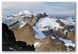
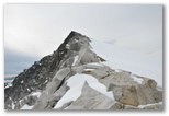
Glacier, Luahna and Baker (in distance) from summit
South ridge and White River to my left. Ascent ramp and gully to my right.
As I reached the summit a falcon soared overhead. I dug out my binoculars and identified it as
a prairie. Shortly afterwards a second prairie sailed around the shoulder of the summit and out
over the glacier, then doubled back and flew low over my head, as if curious about me. I
wasn't expecting the close flyby so didn't have the camera ready. The views are fine from the
summit, north to Baker and south to Rainier, west to Glacier and Sloan Peak, east to Mt Maude
and the Entiat mountains beyond the Napeequa and Chiwawa valleys. The White River runs practically
underfoot, two miles away and 6000' down.
The breeze from the west was cold, 33F by my thermometer, but I lingered on top long enough to
eat some bread and sardines for lunch before starting down. Then I didn't descend very far before
stopping in a sheltered spot to call Susan again. She was going to get me a weather forecast and
she did - it might rain. I suggested I might like to spend an extra night out and that was fine
with her. The roofers were making an awful commotion, scaring Puss into hiding all day. Susan was
planning to get out of the house tomorrow and go have lunch with David. While we were talking a
redtail circled up over the meadow slopes a couple thousand feet below me, then a golden eagle
soared up from the valley and did a couple of roller coaster dives off to the west. Not many
other birds around - a few varied thrushes, chickadees, golden-crowned kinglets, pine siskins,
robins. Haven't seen any mammals other than pikas. It was nice to talk with Susan, and took the
edge off my solitude.
View west to South ridge from top of gully
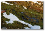
Sunset on moss at 7000'
I descended the ramp on snow, scrambled up the gully with no difficulties, used snow to cushion and
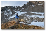
Starting down into Boulder Basin
brake my descent back into Boulder Basin. Back in camp two hours from the summit of Clark, I boiled
water and prepared ancient Vegetarian Lasagna. It was still quite good but I accidentally stepped
on it while it was rehydrating under my sleeping bag and made a mess of a couple of (fortunately
extra) long-sleeved tech shirts. Better the shirts than my sleeping bag. I crawled into my bag
at dark and wrote for a couple of hours. At bedtime the stars were still bright, a gentle 35F downslope breeze
was blowing and the night was silent except for the everpresent sound of falling water. I lack a
word for that sound; perhaps the Bible describes it best as "the voice of many waters".
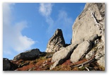
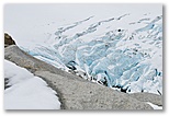
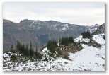
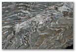
10/30/2008 Boulder Pass 12 mi, 2800' Overcast, high 30's, wind W 0-5 Route (miles 12.7-16 and 8.3-0)
South side of the East ridge of Clark Mt, from 5900'
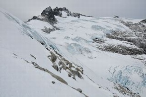
North side of the East ridge of Clark Mt, from 6600'
The two photos above show the dramatic difference between the southeast and northeast slopes of the
east ridge of Clark Mountain. Both photos depict the same three crags on the east ridge of Clark
above Boulder Basin. The photo on the left is taken from 1.2 miles ESE of the nearest crag while
the photo on the right is taken from 1.0 miles ENE of the same crag. Treeline on the slope in the
left half of the left photo is at 6400' which is about the same elevation as the crevasses in the
lower right corner of the photo on the right. Apparently a little sunshine makes a big
difference.
I didn't sleep as well as I did on my first night in. Again I woke up before dawn and waited to get
up until I could see by the light in the sky. The altostratus overhead acquired a pink tint briefly
before reverting to gray. No wind, 35F on the thermometer but the air felt warmer than that. I ate
my granola then set out on a day hike up to Boulder Pass then either drop down into the Napeequa valley
or climb up to the 7200' point on the east ridge of Clark Mt directly above and one mile north of my camp.
My inclination is always to hike up so it was hard to get excited about descending 2000' down to the
Napeequa river. I expected alot of snow on the east side of Boulder Pass as well and didn't look
forward to having cold wet feet all day. Leftover fatigue from yesterday confirmed my decision to
stay high; that way too I could keep my option open to hike out today rather than camp another night
if the weather threatened rain. I ended up hiking in snow most of the morning anyhow but my feet
were OK.
Boulder Basin, camp near bottom of photo
Boulder Pass, Napeequa valley beyond
I hiked up to the right side of the headwall above Boulder Basin to scout for a direct route up to the 7200' point; it looked feasible on
the map but up close it involved at least class 4 scrambling. I traversed instead northeast up
steep meadows above the pass then continued north across a snowy boulder field on the east side
of the ridge, crossing above a small but still intimidating headwall then up an easier slope to the
northeast ridge of my target peak. Interesting rock, alternating between massive white granite and
gray schist with lots of convoluted layering. Ledges of the schist fractured in such a way as to
make for easy scrambling while the jointing in the granite tended to produce larger blocks which
were more difficult to negotiate. I crossed over the ridge by following a contact line between the
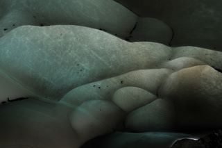
two rock types and found a big snowfield on the other side - the stationary east end of the Clark
Glacier. The gentle slope of the glacier provided the only feasible route up to the 7200' point.
About a foot of settled and slightly sticky new snow lay on the icy surface of last year's snowpack,
enough to cover but hopefully not fully conceal any crevasses. I probed suspicious spots with
my ice axe as I hiked up but didn't expect or encounter any problems other than a schrund at the
summit which I was able to work around.
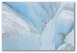
Clark Mt behind Clark Glacier
The 7200' point
The flat light and bright overcast had made bleak conditions for photographs on the way up to the
pass but worked much better for me once I reached the snowfield, accentuating the patterns of snow
ice and rock. I took lots of pictures. The peak was a narrow ridge of granite blocks encrusted
with black lichen on the windward, snow-free side. There was no wind and no sound except for the
hush of falling water wafting up from the valleys.
Although a little chilled, I lingered on top to
eat a lunch of kippered herring, bread, tomato and dark chocolate. After lunch I hiked down the
snowfield hunting for photos. The new snow cover thinned to a few inches but was just sticky enough
to hold on the old ice as long as the slope didn't get too steep. I hiked out to get a close-up
view of a nearby crevasse, picking my route to minimize the risk of sliding into trouble if the snow
didn't hold. On the way back my axe twice plunged into a skinny little crevasse under the snow.
That got my attention! I wanted to reach a set of crevasses at the edge of the glacier below me but
the only route down crossed ice-covered ledges which I didn't want to tackle without crampons so I
settled for zooming in as best I could.
I followed ledges back up to the ridge and descended to the east side of Boulder pass on a series of

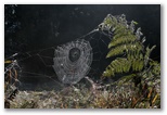
Spider on snow below Boulder Pass
Ridge east of Boulder Pass
rounded ridges of eroded schist vegetated with grass, sedge and mountain heath. Snow-free and easy
walking, particularly on level places where Glacier Peak pumice had accumulated. When I reached the
trail it was decision time. If I headed back to camp I would still have enough time to hike out by
dark but if I dropped down to scout out the Napeequa valley I would be committed to spending another
night in Boulder Basin, and by the look of the sky, would be hiking out Friday morning in cold rain.
If I'd had my flyrod I probably would have hiked down to the river but I didn't, and the light was
flat and the overcast thickening so I hiked up over Boulder Pass and back to camp. It turned out to
be a good decision; based on a webcam view of rainy Lake Chelan the next morning, Boulder Basin
would have been very wet.
I cooked up some ancient Fettucini al Leonardo for an early supper and boiled up some extra water
while I packed up camp. I brought a water filter but it was easier just to boil extra water for
drinking. The air had warmed up into the low 40's and much of the snow around my tent had melted
away. Overhead the clouds faded into featureless gray and the peaks and ridges began to fade with
them.
I had intended to start out before 3 but didn't leave until 4 so again the last hour of my hike was
after dark. I reached the White River trail junction at 5:45 just as I had on the way in. A half
hour later I had to dig out the headlamp. From that point on I sang to alert the bears of my
approach, or maybe to scare them away. At first my singing seemed very out of place among the big
shadowy firs but as I considered the meaning of the hymns I was singing, it began to feel
appropriate to praise God out there surrounded by His forest, His mountains. I also discovered that
I'd forgotten most of the words to the hymns I knew back when I was more fervent in my faith. After
I ran out of words I whistled instead. Either way my noisemaking apparently worked because I saw no
bears, only a large white rabbit which zig-zagged off into the darkness ahead of me. I reached the
car soon after seven. The 8 1/2 mile hike out and the 150 mile drive home each took 3 1/4 hours.
 Strange dream the night before last: